
Google My Maps is an application used to create customized maps online, as a visual data-organizer, allowing researchers to view their data in a map on their research material. As a mapping application in general, it is extremely beneficial for analyzing texts with real locations. As you will see, Google My Maps can also bring fantasy books to life by helping us locate real places to the settings of fantastical stories. This tool could be used to map the different books people read over time, and help locating places mentioned in those books. It, therefore, allows you to have a clearer understanding of the texts you are reading and a nicer picture to the events occurring in those books. It has so many interesting features, including colors, icons, videos and images to help mark a specific location. It allows you to customize and personalize the locations identified which is even more interesting.
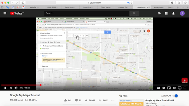
In this blog, we will be taking you on our journey encountering Google My Maps for the first time. We first decided to watch the following tutorial on youtube.com: Google My Maps Tutorial(https://www.youtube.com/watch?v=fLhyr5MGi2g&feature=youtu.be). It is a very helpful one as it clearly explains all the features that could be used in Google My Maps and the different use cases for this tool. After carefully learning the instructions from this tutorial and due to the current lockdown situation in Lebanon, we created a Google My Maps sheet and shared it among us three. Then, we each created his/her own layer and started experimenting with places and locations relevant to our topic. In parallel, we discussed our findings and analyzed their relevance to the theme which we adopted: “Heroes vs Monsters”. The following link will take you to the mapping of our literary texts using Google My Maps: https://drive.google.com/open?id=1mWyNP9WNqhLXfIyBpJR9cQoMYSoDr1al&usp=sharing
As per the latter, we decided to work on four different texts/books: “Sleeping Beauty” by Charles Perrault first published in 1694, then filmed by Disney in 1959. We put its analysis in contrast with “Maleficent”, the counter-story portraying the villain of the latter as the protagonist of her story, filmed by Disney in 2014. Then we looked at “Batman” of the 1960s and put it in contrast with “The Joker” drawing attention to the then-villain in Batman, published in 2019. We closely read the texts from Gutenberg.org, DC Comics and IMDb (https://www.imdb.com/title/tt1587310/plotsummary).
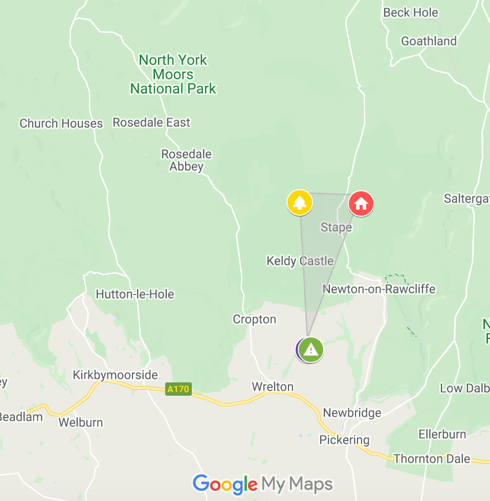
The texts/books that we chose for our Google My Maps assignment are all from different authors and include undermined spaces or places of action which are not normally seen in the world. However, to our surprise, we found that most of the spaces mentioned in the stories actually do resemble earthly spaces, such as Gotham City found in both Batmanand The Joker. This location is actually a city in New Jersey, US. Also in Maleficent, the main character, Maleficent herself rules over a kingdom/magical forest called the Moors Forest in the text/film. There effectively exists a Moors forest in North York, UK. Therefore, we speculated that the events of those stories all happened in or near those real-life locations.
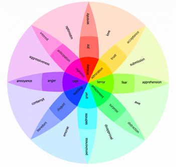
To pin our locations we decided to use icons that reflected the scenery and colored them using the Plutchik’s wheel of emotions.
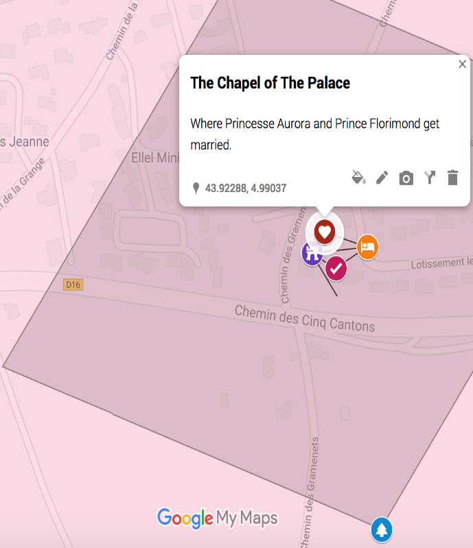
Through the mapping exercise of Sleeping Beauty and Maleficent, it became evident that both stories occur in the eastern part of the world, most precisely in Europe. The narrative of Sleeping beauty takes place in France, Avignon. This assumption is based on further research on that book that shows where the main events of that story happen (source:https://www.radiotimes.com/news/2015-09-04/this-google-map-shows-where-your-favourite-disney-films-are-set/). The zones of action in Maleficentare spread over the area between the forest, the castle, the dungeon of the castle and the cottage. They are somewhat distinct and each representative of a phase in the story (e.g. cottage = where Princess Aurora was raised until her 16th birthday and where Maleficent would visit from time to time). In contrast, when mapping the zones of action for Sleeping Beauty (an older version focusing on Princess Aurora as the main character), we realized that most of the events happen in the same space: the palace. The forest is no longer on the border of the kingdom, but it surrounds the palace as a form of protection from the outside world (while the princess was in her 100 years slumber). This story focuses its actions in a narrower space to shed the lights on the importance of that location relative to the message of the story. In Maleficent, all locations mentioned meant something to the Heroine (formerly considered a villain in Sleeping Beauty).
Regarding the mapping of Gotham City, for the series of Batman: at the beginning, the map doesn’t really appear as either “true” or “accurate” as we expected it to be. Regarding the mapping of Gotham City, for the series of Batman: at the beginning, the map doesn’t really appear as either “true” or “accurate” as we expected it to be because Gotham city is fictional and all we know is that it could be in New Jersey, US
(https://en.wikipedia.org/wiki/Batman_(1966_film) – https://en.wikipedia.org/wiki/Joker_(2019_film) – https://en.wikipedia.org/wiki/Gotham_City).
By looking closely into Gotham and the details of the story of Batman, we tried to map the most iconic monuments and places in the Batman Series.
As a final result, Google my maps helped us create and understand more about Gotham city and the adventures of Batman. By mapping all the iconic sites within exact distance of each other (for example, mapping the “Blackgate Penitentiary” 12 miles from the “Arkham asylum” or “CRIME ALLEY”; The worst moment in Batman’s life came when the young Bruce Wayne saw his parents shot and killed by a mugger, which happened in Crime Alley) you get a more concrete image of the city. All the time imagining the places, alleys, buildings that Batman interacts and adventures himself in the books, they become clearer in your mind.
So, by mapping those childhood memories on a 2D platform, we experienced a batman story in a different way. Placing and mapping all of batman’s path and event restructured our mindset about the events and gave a deeper understanding about all the challenges batman encountered in Gotham city. The fact that the setting of that story were actual places in the real world lifted our interest in the character and his story and directly made us want to know more and probably visit those real life places someday. Google My Maps brought fantasy to the real world and this is why our experience with it is exceptional.
To be able to map all those fictional locations on a real map, we mainly relied on Wikipedia to search the most relevant places in the DC world, especially for the Batman Series and The Joker: “Gotham City is traditionally depicted as being in the U.S. state of New Jersey. Over the years, Gotham’s look and atmosphere has been influenced by cities such as New York City and Chicago.”
We were able to locate to real locations that have been used for the batman series:
- Wayne’s Manor: It’s just up the M42 motorway from Birmingham. That’s because Wollaton Hall in Nottingham is the real-life Wayne Manor, and appears in The Dark Knight Rises blockbuster. Bruce Wayne’s place of residence is Wayne Manor, which is located on the outskirts of the city. His butler, Alfred Pennyworth, aids Bruce in his crusade to fight crime in Gotham.
- The Batcave: The actual cave that the Batmobile is shown emerging from (and sometimes entering) in the TV show is in the man-made filming location known as the “Bronson Caves,” in Griffith Park, below the Hollywood Sign. The Batcave is a secret underground base for batman. All of his vehicles and advanced weaponry and gadgets are all in that same place including his famous armor and mask along with the Batmobile. This said, the Batcave has a secret entrance as well as secret exits so that batman always is unnoticed.

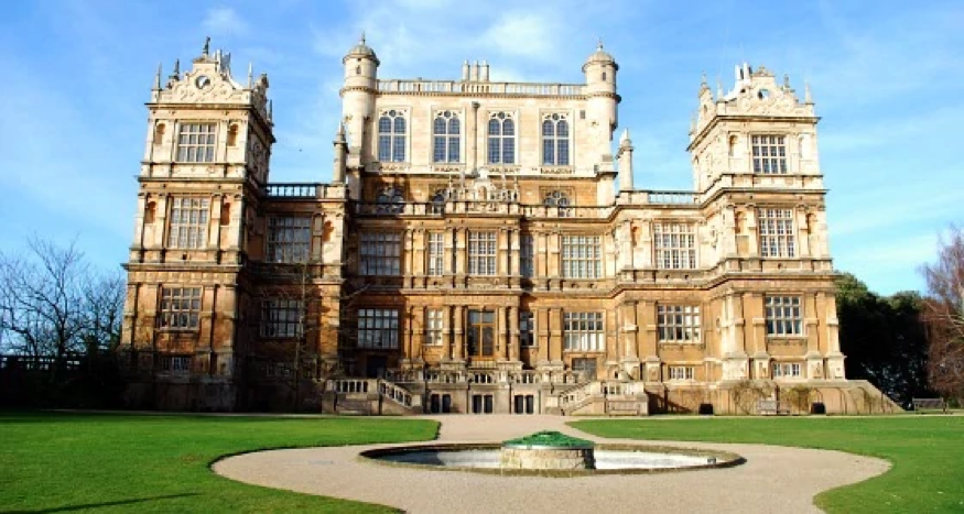
Real life Batcave location via tripadvisor.fr – Bruce Wayne’s Manor via batman.fandom.com
Google My Maps has many advantages when it comes to the presentation of the material. Firstly, it is straightforward and user-friendly. In our case, we used it to map out a set of events happening at fictional places. So, we as users had to change the headers, add descriptions respective to our research and the data we wanted to present and mark the locations. After marking the locations, we had to link emotions – an interesting feature; for instance, anger could be highlighted in purple, etc. Such a feature allows a more personalized experience for the user and for the audience later on. We would highly recommend using it to enhance a presentation as it makes it more appealing to audiences.
Since Google My Maps is very beneficial as it allows us to infer complex relationships between the inserted information and make them clearer and more relatable, we will use it to show the relationship between series of events leading to a certain outcome related to our theme. For example, using Google Maps in narrating the story of “TheJoker” has showcased all the significant series of events in the story clearly; highlighting the important part of it; thus, making it clearer how all the events have contributed to turning him into the man he is today; also, making him the hero of his own story. In conclusion, this tool made us believe again in the realness behind every fictional story and the relatable events that can lead a person to behave the way they do – which results in them being looked at as either heroes or monsters (i.e. villains).
Done by: Alexia Al Alam, Ghida Allam, and Joseph Abboud
